Saving and printing your maps and tables
In this version, maps can be printed out in several ways. One way is to
install an image capture software capable
of capturing rectangular portions of the screen, and use it to save your
maps as they appear on screen, as image files. There are literally hundreds
of image capturing utilities, shareware or adware ('adware' is free software
that displays some commercial advertising while you use the program), available
at www.download.com.
We would recommend Capture Express 2000, an adware, for its ease
of operation and multiple useful features. It's free. You can download
it as a self-extracting file from here, or from
the previous link. Run the self-extracting file, install and configure
the program (i.e. select the hot key, destination format, etc.). Once the
program is running in the background, you can invoke it at any time by
pressing the hot key, and capture arbitrary portions of the screen in various
graphic formats, save it on the clipboard, or even e-mail to someone. Once
captured, the map can be saved or printed from within any application,
as an image file.
If you need to save attribute tables, or tables of selected records,
save these tables first as html files. Then you can open them in a spreadsheet
program such as Microsoft Excel, edit and print.
Print layout window
Another way to print from within AxioMap is via the Print Layout
Window. Open this window by clicking the Print button at the bottom
of the left frame. A print layout window will open (it may take a few moments
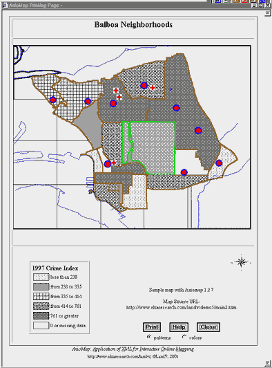
if your map is large). Notice that if you are displaying a statistical
thematic (choropleth) map, the colors of individual categories are now
replaced with black and white patterns (see picture)
 The
print layout has several components:
The
print layout has several components:
Map Title: same title as in the original map. Click on the title
to edit it if necessary
The map itself. The map is formatted and positioned to fit on
a standard letter-size sheet, with portrait orientation. Note that colors
used for choropleth thematic mapping are replaced with patterns. You can
select different patterns by editing map legend (below)
Map Legend (if appropriate): You may click patterns in the legend
to open a pattern selection window (see picture)
 If
the map is rendered in color, clicking colors in the legend will open a
similar color selection palette
If
the map is rendered in color, clicking colors in the legend will open a
similar color selection palette
Map annotation (from the original map) and its URL. Like
before, you can edit these texts by clicking them with the mouse
The Print, Help and Close buttons, and color vs b/w design selector.
Though these buttons appear in the layout, they are not printed.
We do not recommend printing from the browser without using the layout
as results are unpredictable.