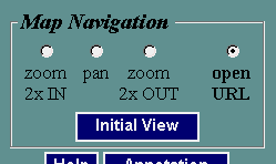
When a map is displayed in AxioMap , you can change the map extent and the area you are viewing using zoom or pan.
These are the map navigation elements you can control in the left frame:
To zoom in: make "zoom in" active, and click anywhere within the map where you want to zoom in. The map will be redrawn centered on the place you clicked, and magnified according to the defined zoom level.
To recenter (pan): make "pan" active, and click within the map where you want the map centered. The map will be redrawn centered on the place you clicked, without any change in scale.
To zoom out: make "zoom out" active, and click anywhere within the map where you want to zoom out. The map will be redrawn centered on the place you clicked and scale decreased according to the zoom level.
To return to the initial map scale and extent, click "Initial View"
Note that when you open the map for the first time, it is in the "Open URL" mode, and you will need to select either the "zoom in", "pan", or "zoom out" mode to make navigation work.
When your map is in one of the these three modes, the status bar displays your mouse position in map units (decimal degrees, if your map is in "geographic" projection, meters if your map is in UTM, etc.)
The default zoom level is 2x. To change it, select a zoom level value from the zoom level control under Settings (see below). The labels under the "zoom in" and "zoom out" radio buttons will immediately reflect this change.